As you can read in my blogpost from 5 aug, I am studying on how to improve for a "floatplan" when walking the Norwegian mountains.
Out of several options to improve, I started investigating on using the possibilities of GPS; thinking about "real time tracking" thus giving a contact-person the possibility to follow my progress and position.
Searching the world wide web for information, I was astonished about the latest developments with GPS. Everything you can think off seems possible already.
Since GPS is, or can be, a good supplement on seakayak-equipment, I would like to share with you the result of my quest for information.
First I would like to try to answer the basic question: What can a (handheld)-GPS mean for seakayakers?
- A GPS can be a safety backup: you are able to communicate your exact position when help is needed.
- A GPS makes navigation very easy; in the eyes of some of us it may be too easy.
- A GPS makes you learning while studying your recorded trip afterwards, so you can evaluate your plans against what you did out at sea. Thus making it possible to learn and improve next time.
- In bad weather the use a GPS can make you feel more comfortable, since you have the possibility to paddle the shortest route and preventing being swept away. It will or can be energy saving for your arms (see: blogpost Douglas Wilcox # click here]
- A GPS is a great tool for measuring your paddling speed and -progress; thus giving a clear indication wether your goal can be reached or not, in a given weather- and/or current-situation. This gives you the possibility to change plans in an early stage thus preventing coming into a difficult situation.
There are also downsides in the use of GPS:
- There is a risk of making yourself dependent to the GPS, not learning or practising anymore in navigating yourself
- The batteries can run empty, making it necessary to take over navigating manually. Something you must be able to of course and which is a problem if you completely depend on it.
There are kayakers who do not like it using a GPS. Most arguments heard are:
- Navigating without GPS is a challenge and fun to do.
- Frequent looking at the display makes you look less to the surrounding nature, thus making you less enjoying your trips.
- Once the GPS stops working, for some reason or another, there is risk to run into trouble.
Personally I think there is a truth in these arguments. But certainly a GPS can add to the safety of the sport.
I am still feeling a bit double about "what to have or not to have".
Basically I think that I would like a device that:
- Gives me the possibility to backtrack a trip afterwards: for evaluating purposes. But also for making maps in trip-reports.
- Gives me a speed indication and progress in km's or n.miles.
- Gives me the possibility to read my exact position while paddling.
- Can give a distress signal, accompanied with coordinates.
On the other hand, when paddling under difficult circumstances and in unknown area, I think I could appreciate the help of a GPS.
But also: all these technical developments and possibilities are "nice to have" and to play with.
Underneath I describe an overview of the information about the GPS-based-devices that I found while studying the possibilities with a GPS. I included only the options that could make sense for seakayaking. Of course there are more applications, like in use in the army- and weapon-world, but these I did not include in my study.
I devided the information into the chapters:
- Navigation
- Recording
- Measuring
- Communication
- Distress
- Real-time tracking
NAVIGATION
I found the "Normal handheld GPS".
These are available in a basic version giving you possibilities to work with co-ordinates, to program routes, to perform goto-action, backtrack, measuring speed and progress, recording.
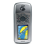
These GPS-devices are under quick development and there are also more advanced GPS to be found: having a display showing maps, visualising real-time where you are exactly.
Most modern GPS-devices can be connected to a PC making programming of waypoints and routes (in a map on your PC-screen) as well reading-out recorded trips very easy.
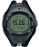
There are even GPS wristwatches available: probably rather basic (without the maps yet), but nowadays offering the possibility to backtrack your routes and project them afterwards on maps or Google earth-satellite-pictures
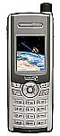
A logical development is also a GSM-telephone with GPS in it. It seems a matter of time to have these phones with the same possibilities as the most advanced handheld GPS.
An example of a modern GPS with mapping is the Garmin 76Csx [www.garmin.nl/]
An example of a wristwatch is the Suunto X9i [www.suunto.com/]
RECORDING
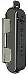
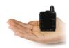
Next thing I found is the GPS stick, which is a device with the size of a USB-stick.
This stick only records your progress, making it possible afterwards to backtrack your trip once at home, even offering the possibility to project your tour on Google earth-satellite-pictures. It can record up to 18.000 positions and can work non-stop for a month. This is ideal for evaluating your trips afterwards
An example of such a device is the Trackstick[http://trackstick.com/]
MEASURING

Another simple device is a GPS with a small display, just big enough to read out your speed, distance and the actual compassbearing you actually follow.
For those under the seakayakers, who like to navigate manually, this could be a helpfull device because knowledge of these parameters can help you with decisions while navigating: because you know exactly what you are doing and what the influence of wind and/or current is on your progress and actual direction.
An example of such a device is the NavMan M300 [www.navman.com/]
COMMUNICATION
There exists the combination of a satellite telephone + GPS.
I did not yet find out what the possibilities of the GPS part are, but certainly this is a very safe combination, making it possible to communicate wherever in the world about your position.
An example of such a device is the Thuraya satellite-telephone [www.thuraya.com]
At paddling places where your cell-phone works, the same result can be reached with the GSM+GPS-combination.
DISTRESS
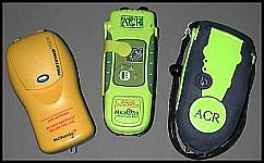
As an extension of the EPIRB there exists a device (containing a GPS and a satellite-transmitter) that can send a distress signal together with your position-coordinates.
This is all it does, so you can not read out the device.
An example of such a device is AquaFix 406 GPS I/O PLB available at [www.whitworths.com.au/] or [www.oceansafety.com/]
REAL-TIME TRACKING
The (beginning) possibilities are that your position and progress can be traced or tracked in "real time", making it possible for someone else to log in on a computer somewhere in the world and notice where you exactly are that specific moment.
At places where the GSM-telephone works, there are possibilities to get a specific phone to be traced. There are organisations who can take care of that against a subscription and yearly fee.
An often used possibility is the combination of GPS and GSM in cars making it possible to trace cars real-time. Of course this only works when a GSM-network is active.
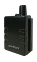
For outdoor-use Anytrack [www.anytrack.com] offers a handheld device (GPS100) for this purpose that works on cellular phone-base(GSM).
Brand-new is the possibility to have the same done via satellite-communication, extending the tracking to the whole world.
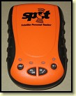
Recently a device is invented, named SPOT, which is a combination of a GPS and a satellite-transmitter.(no receiver)
It offers 4 functions:
- A distress button: sending a distress signal accompanied with your position-co-ordinates
- Asking help function sending an SMS with your position-co-ordinates to predefined addresses
- Sending an SMS with your position to predefined addresses and at predefined interval
- You can be traced real-time, only if you like, once you subscribe to do so; to a certain fee.
Unfortunately this device does not record, so you can not read out the device afterwards. But the possibilities as offered are superb. The device is availble at [www.findmespot.com]
CONCLUSION
Although everything seems possible in GPS world, it seems impossible to have yet 1 device that does it all.
The choice is yours!